Yant Flat – Candy Cliffs near St. George
 It all started a couple of years ago, when Steffen found an image on the web of an interesting looking place with the vague description “at the foothills of Pine Valley Mountains”. He saved it on his computer, but then… guess what!? He totally forgot about it and never showed it to me…! It wasn’t until we got an email early last year from a local offering to guide us to a remote unknown crazy sandstone area near his home in the St. George area without mentioning any further details. That’s when that place at the foothills of Pine Valley Mts instantly came back into Steffen’s mind and he told me that he probably knew what this local was talking about.
We were on a phototrip during that time, but back home Steffen showed me what he had saved on his computer and we were surprised how easy it was to locate it on Google Earth now. A few years ago the resolution was so bad that Steffen was not able to see anything, but now the place “at the foothills of Pine Valley Mountains” was there and looked absolutely incredible to me – just like a combination of White Pocket, Yellow Rock and Valley of Fire‘s Rainbow Vista area seen from above. The moment I laid my eyes on it, this place was high up on my bucket list. So glad the next Southwest trip was coming up!!! 
And we did what Steffen and I always love to do most: find and explore places on our own. Steffen looked for the right roads leading there and I took note of the GPS waypoints of the most colorful spots at the cliffs. Parts of it seemed pretty steep to me. So much looking forward to heading out there and seeing it in real life!
And it all happened much earlier than scheduled because our car did not perform well at the Paria Plateau (the Toyota RAV4 was the most miserable SUV we’ve ever had… so far…  ). We skipped our motel reservation in Kanab and headed to St. George hoping for a wonderful sunset at the “new place”.
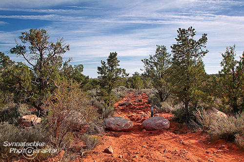
Arriving way too early, we unfortunately missed the meet-up with Michael, the local who wanted to guide us there. So we needed to search for it on our own. We had found a spur track leading directly to our target cliffs on the satellite images and that’s why we drove back and forth the main forest road. There was obviously no jeep trail anywhere, but after a while we saw a National Forest sign in the woods prohibiting motorized access. We parked our car nearby and followed by foot an old, now totally destroyed road. After a couple of yards we were back on track and the road was visible again. This was the old jeep trail leading to the cliffs we were looking for.
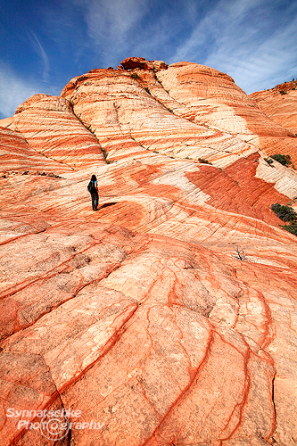
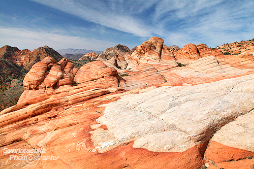
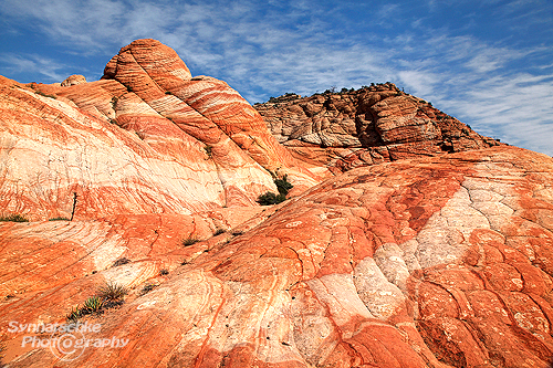
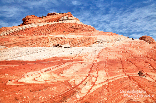
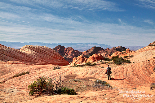
And what a breathtaking sight, when we arrived at the edge of the cliffs! It was in fact a perfect combination of our favorite “wonderland of rocks” in the U.S.: the buttes, bowls and cross-beddings reminded us of the Coyote Buttes, the patterns and swirls looked like White Pocket or Crazy Hill at Valley of Fire and in the distance way beyond the steep cliffs there were another fantastic landscapes, the towers of Zion National Park. The colors were not as bright as in the Coyote Buttes or in Valley of Fire, but the whole scenery was just incredible. And with all these prominent stripes, dots and fancy shapes, I couldn’t help thinking of a giant “candy shop”.
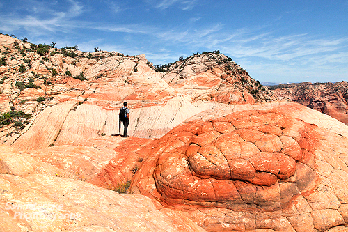

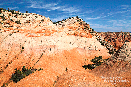
I am sure, not only sandstone aficionados will like it there. Especially at the area where we found the “Sandstone Eye” (37°12’55.5”N, 113°28’07.5”W), the surrounding hills look just as if an artist had accidentally spilled his palette of paint all over the place. Do not expect any very fragile sandstone formations there, this place is more about patterns and beautiful scenery. The area you might want to explore is just about 1 km (0.6 mi) in length up to a big dryfall at 37°13’13”N, 113°27’23”W, but there are a lot of ups and downs in between and some steeper sandstone bowls as well requiring good hiking shoes and maybe a little bit of scrambling too. Be sure not to miss the swirls on this hillside 37°13’00”N , 113°27’50.5”W. And these two GPS waypoints may help you finding the slope we used to get back to the upper plateau and get further east to the above mentioned big dryfall: 37°13’5.28″N, 113°27’43.52″W and 37°13’7.15″N, 113°27’40.72″W.
Heading back to the car (cross-country or the way you came in), you might still visit a very special and colorful place at Yant Flats, a small “Yellow Top” with gorgeous patterns all around it (37°13’04”N, 113°27’24.5”W). For us this is surely one of the most scenic spots along the rim. But the access is not easy to find and it’s a rather strenuous sidetrip. Some scrambling and bushwhacking is involved between the upper plateau and the second plateau before heading down to this yellow hill. Please take care, the steep drop-off towards southeast is pretty scary in places!
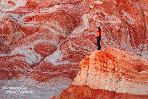 You will definitely need a couple of hours for the whole hike and way more if you intend to do some shooting at the Candy Cliffs. Since the edge of the plateau faces southeast the best time for photography here is at dawn or during the morning hours. I also liked it there shortly before sunset, when only the top of the “Crazy Hill” at the Candy Cliffs was lighten up. Couldn’t resist catching that one again with a person for a better size comparison.
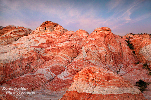
After a wonderful sunset we had dinner at the Golden Corral (their buffet is better than some Las Vegas buffets and pretty inexpensive; all you can eat buffet with steak for about $10) and a good night’s sleep at the Quality Inn in Saint George (Exit 6 from I-15). The next morning the clouds looked even crazier than the day before, so we could not resist stopping again at Yant Flat for more explorations and photos. I once named one of my images from White Pocket “land of confusion”, I guess here at Candy Cliffs I could have written “land & sky of confusion” as a subtitle for every single image we took. What a great place and what a great storm front! We felt so lucky!
Brief summary: The Candy Cliffs near Yant Flat are a fantastic place well worth visiting and spending a couple of hours. Photographers and sandstone aficionados will love exploring all those slickrock bowls and crazy sandstone patterns. And it felt so good being out there all alone with nature again in a place way off the beaten tracks. We will hopefully be back soon!
And talking about rather unknown places… I guess this whole story also showed me that there is one thing I should definitely do before heading again to the Southwest or even before looking for new places at satellite images and in the internet: “Take a closer look” and “explore” Steffens hard disk…!
 Directions to the trailhead: Yant Flat and Candy Cliffs are located northeast of St. George within Dixie National Forest and accessed from an improved gravel road. Coming from St. George you’ll leave I-15 at Exit 22, drive the Main street through the town of Leeds for about 1.5 mi until making a left on Silver Reef Road near Exit 23. You may use Exit 23 if you are heading south on I-15 only. Reset your odometer here at the junction Silver Reef Road / Exit 23 and drive northwest for 1.1 mi where Silver Reef Road bends to the left and you’ll keep going straight on Oak Grove Road (FR 032). The pavements ends after 1.5 mi, but the gravel would have been even passable with a regular passenger car, when we were there last fall. You will see a lot of dispersed camping areas along the roadside (maybe a good place to spend the night if you intend to do an early morning or late evening visit?). Further uphill there are some windy, narrow switchbacks, so trailers or RVs are not recommended from there on. After 3.1 mi keep left at the intersection of the forest road 032 and 031, following the sign that says “St. George 24 mi”. When your odometer shows you are about 10.4 mi away from Exit 23, you will see a dirt road leading to Pine Mountains on your right hand side (FR 903). You arrived at the trailhead (37°14’05”N, 113°28’37”W). Leave your car on a place where it does not block traffic and start your hike on the left side of forest road 031.
Required time: more or less 30 min from Exit 23 or 45 min from St. George.
For driving directions please also check our map contained in the zip-file, by clicking on the Topo icon below.

The Trail: There isn’t any established hiking trail across the sandy and bushy Yant Flat plateau to access the cliff area. Starting at the unsigned trailhead you can either hike along the old jeep trail and then navigate cross-country to this GPS waypoint 37°13’06”N, 113°28’03”W or simply continue following the former road up to the cliffs (1,8 km/1.1 mi). It is only a small detour and without a GPS device the safest and easiest way to get there – even without any route finding skills. Personally I do prefer this access since this place is pretty remote and seldom-visited (at least up to now) and I am sure rattlesnakes abound in the undergrowth. By following the old road you’ll have to hike along the cliffs for about 600 yards (~550 m) heading northeast until you reach the same slope that gives you easy access to the Candy Cliffs area (see GPS waypoint above or image on the right). At that slope you are almost there, just 200 yards (~180 m) away from the “Sandstone Eye” our favorite area at the Candy Cliffs.
There is also a hiking map in our zip-file, please click on the Topo icon below (all GPS waypoints in WGS84/NAD83):
Back to St. George: Forest road 031 leads back to town, but it deteriorates very badly shortly after the trailhead. Not sure if this road is usually maintained or not. But in case you have a 4WD vehicle and want to take that road to St. George as a shortcut better inquire at the Interagency Office (345 East Riverside Drive, Tel: 435-688-3246) first about the current road conditions. We refrained from going that way with our “rented wreck”.
• Pine Valley Mountain Wilderness
• Road Map of Pine Valley Ranger District
• Steffen’s German version of the story with some additional images (Candy Cliffs at Yant Flats)
Wow, das ist ja mal wieder eine super Gegend, die ihr da entdeckt habt, die Fotos sehen fantastisch aus. Mein Favorit ist das 6. Bild, der Blick ist echt genial.

Da hat sich ja das Warten auf den langersehnten Bericht durchaus gelohnt – vielen Dank für die toll aufbereiteten Infos !
Ist schon irre, was da so ganz in der Nähe von einer so großen Stadt liegt und es bisher noch keinerlei Berichte darüber gab. So etwas überrascht mich doch immer wieder…
Falls wir jemals wieder irgendwann in den Südwesten kommen (kann vermutlich noch eine Weile dauern…) wird da auf jeden Fall ein Stopp eingelegt, das ist klar.
LG, Tilman
Uiuiui das ist ja mal wieder der Hammer! Das sieht doch tatsächlich so aus, als könnte man sich da eine Weile austoben Lustigerweise hab ich sogar ein paar Fotos von der Gegend, allerdings aus einigen Kilometern Entfernung vom Hurricane Rim Trail aus aufgenommen (http://bjoern.netzfuxx.de/mtb/trails/hurricane/slides/02-Bridge.php), da sind mir nämlich damals auch diese roten Klippen aufgefallen, als ich dort mit dem Bike unterwegs war. Aber auf die Idee, mal dorthinzufahren, bin ich nie gekommen…
Danke für den tollen Bericht und viele Grüße aus KA,
Björn
Danke Euch beiden!


Tilman, ich denke schon, dass Ihr in diese Ecke doch bald wieder mal hinkommt. Denke mal nur an den kleinen Hannes und wie oft er schon drüben war…
Und Björn, ja das sind wohl die Klippen von der anderen Seite. Diese ganze Gegend, auch rund um den Snow Canyon ist toll, da müsste man noch viel mehr herumwandern, glaube ich!
LG an Euch beide,
Isa
WOW, einfach nur WOW!


Genialer Bericht und geniale Fotos. Das kommt auf alle Fälle auf die ToDo Liste für den nächsten Urlaub. Danke für den Bericht!
Liebe Grüße
Richie
Klasse Gegend. Habe schon mal Flickr ein bischen was davon gesehen. War so ein Outdoor Team. Die Bilder waren aber nicht so schön wie die euren. Saubere Arbeiten wie immer in gewohnter Quali.
Ich dachte mir schon (bzw. hatte es gehofft ), dass die Gegend Dir/Euch zusagt, Richie! Und ich hatte Dir ja versprochen, dass es nicht abseits Eurer nächsten Route durch den SW liegt.


Auch Dir Thomas und Andre lieben Dank für Eure Kommentare. Auf Flickr kenne ich da eigentlich nichts, da wäre ich neugierig auf einen Link, Andre. Denn die Suche findet dort nichts. Bei Panoramio gibt es aber neuerdings ein paar Bilder von Yant Flat.
VG und eine schöne Woche Euch allen!
Isa
Wow klasse, Isa, da fühlt man sich ja gleich in die guten alten Zeiten zurück versetzt, als in halb- oder vierteljahres Abständen solche Highlights auf Steffen´s Seiten auftauchten ;-) , und man nicht wusste wie man am schnellsten einen Flug in den Südwesten gebucht kriegt.
Beste Grüße
Lothar
Hi Isa,
da ist Euch ja wieder ein toller “Wurf” gelungen! Und sofort ist der Bericht in meine Reisemappe gewandert. Möglicherweise werde ich jetzt einen Tag umbuchen müssen, aber ich denke, das ist es wert.
Liebe Grüße aus Sessenheim!!
Danke auch Euch beiden für die netten Zeilen!


Freut uns, wenn Ihr Euch freut!
Lothar, solche Kommentare habe die letzten Tage auch per E-Mail erhalten und ich muss gerade ziemlich schmunzeln… Denn die guten alten Zeiten (als Steffen noch mehr Zeit hatte…) kenne ich nur allzu gut aus derselben Perspektive wie Du und ich habe damals auch immer seine Berichte verschlungen.
Lang lang ist’s nun her… ich fürchte, jetzt beschäftige ich ihn immer viel zuviel…
LG aus DD,
Isa
Hi Isa+Steffen! Mal wieder ein echtes Highlight, so wie man das von Euch gewohnt ist. Und wie der Zufall so will bin ich in 3 Wochen im Südwesten und haben zwischen Valley of Fire und CBS noch “Lücken”. Die dürften damit gefüllt sein. DANKE!
Gruss aus DD,
Daniel
Hallo Isa & Steffen! . Falls wir hin kommen werde ich auf jeden fall über unsere Erfahrung berichten!
 ! LG, Mireille
Es ist schon eine Weile her das wir uns geschrieben haben ( damals wegen ‘the Wave’. wir hatten das Glück diese inzwischen 3x zu besuchen dürfen! Dieses mal bin ich dabei eine kurzreise zu planen. Kein Wave besuch dieses mal… leider, weil davon bekommt man nie genug! Da hat aber noch ein bisschen das gewissen ‘Etwas’ gefehlt in unsere Reiseplan. JETZT NICHT MEHR! So ein ‘zufall’ das ich grade auf euere bericht gestoßen bin! Ein besuch passt perfekt in unsere ablauf und wenn das wetter es zulässt, werden wir auf jeden fall versuchen hin zu kommen! Ich werde mich vielleicht noch in verbindung setzen wenn ich fragen habe aber für jetzt möchte ich euch herzlich bedanken für diesen tollen tip und den schönen Bericht! Also ende April geht’s los
Vielen Dank nochmals
Hallo Daniel und Mireille!
Gern geschehen, wir wünschen Euch noch viel Spaß beim Reiseplanen und dann auch vor Ort!
VG,
Isa
I hike Yant Flat a lot, and I can tell you it takes more than 2 hours to hike there. Usually we travel over half of the cliff area in a total of 5 hours. I’m leading a hike there tomorrow and I expect it will take 5-6 hours. 3 days ago we did a bigger hike there and it w3as 6+ hours, with 700 meters of climbing and descending.
It is a special place.
I agree, John. In 2 hours you will just have a very quick look at the place and if you are not a fast hiker you might only get to the cliffs and back and not see much. That’s why I recommend spending a couple of hours there.
And yes, it is indeed a very nice place out there in the Southwest!!
Hallo Isa,
vielen Dank für den Super-Tipp
Wir haben das “Candyland” für Mitte Mai fest eingeplant!
Beste Grüße
Thomas
Hi,
We’ve seen you’re recent found of Yant Flat !
As we are in the saint George area in september, I’m trying to figure out if this is a possible place to visit. We are dirt road drivers, riding a 4×4 SUV. I don’t think thats the problem. Neither is hiking several km. But walking a lot of descents/elevations is a problem for me. Can you tell me if there is a lot of elevatian gain ?
Thank you very much and congratulations !
Hi Carine
The change in elevation up to the cliffs is not worth mentioning. At the edge of the cliffs there some ups and downs (see images #6 or #7), they are not really difficult and you do not need to go down at the bowls if too strenous for you.
The area around the “Sandstone Eye” is the first thing you will see and in our opinion it is rather easy to reach. You can take a look at the last image it shows the lower part of the cliffs.
Have a safe trip!
I love that area! I have been exploring it for some time now. I try to keep it a secret. When you get to the main area go East ans hike down the wash for quite a ways and you end up in another dimension with purples, yellows, orange, red and white. The colors there are very striking and worth the extra jaunt. I think I have explore every inch of Yant Flats and all along the wonderful sandstone formations. I live only a few minutes away and I consider it to be my back yard. There is so much to see and appease the eye!
Hi Sue
Yes that place is also an amazing part of the Yant Flat cliffs. It must be the one I described as “very colorful spot with some more yellowish patterns”.
You really live in a very beautiful country!
Best wishes,
Isabel
Hallo Isa & Steffen,
vielen Dank nochmal für die “Entdeckung” der Yant Flat. War vor wenigen Tagen dort und ziemlich beeindruckt! Sooo gross hätte ich mir das ganze gar nicht vorgestellt. Hatte leider kein perfektes Fotolicht und mir scheint, dass das alles auch ehr eine “morning location” ist, aber es war trotzdem grossartig! Die Anfahrtsbeschreibung ist aber noch etwas verbesserungsbedürftig Die erwähnte T-Kreuzung ist kaum auszumachen, da es einfach nur ein Abzweig zur FR903 ist. Besser wäre also ein Hinweis auf den Abzweig der Forest Road 903. Genau gegenüber liegt dann der Trailhead.
Wie auch immer… tolle Loocation und definitiv einen Zweitbesuch zur richtigen Zeit und mit besserem Licht wert.
Gruss,
Daniel
Hi Daniel, schön dass Dir das Gebiet gefallen hat. Das mit T-Kreuzung steht hier in der engl. Version nicht, bei Steffen habe ich aber gerade nachgeschaut, er hat geschrieben: “Hier mündet rechter Hand eine breite Piste (FR 903) aus Richtung der Pine Valley Mountains ein.” Kann man eigentlich fast schon so lassen oder?

Du hast Recht im Sommer ist das sicher eher eine “morning location”, im Herbst war das letzte Abendlicht aber auch irgendwie recht nett beim “verrückten Hügel”.
Und gut dass Du “Entdeckung” in Anführungsstrichen gesetzt hast, war ja eher nur eine Veröffentlichung.
Noch eine schöne Zeit und viel Spaß im Südwesten!
Isa
Thank you so much for your Blogposts. I’d never heard of this place. On a recent trip to Utah I stopped by for a quick look and hike. Your directions were right on. Awesome place. Thank you so much.
Thank you, Andrew!
Best wishes and have a nice Sunday,
Isabel
Hi. Great article. I am thinking of visiting this area and found your blog. I was also thinking of buying a Toyota Rav………..is your bad experience of it a general complaint or specific to your particular vehicle????
Hi Christa, no I don’t think all of them are as powerless as the one we had. I also heard good things about this vehicle, but our rental car this time was way worse than any Trailblazer, Explorer, Pathfinder, Xterra or Jeep. And what we did not like at all was the clearance. We never had such a hard drive up to the Coyote Buttes South and for the very first time we were not able to visit White Pocket.
Hope you enjoy Yant Flat!
Best wishes,
Isa
Thanks for the great report, Isa. I am an amputee and want to find the shortest distance to the cliff. Is that along the old jeep trail? From Google Earth it looks like we could drive a bit further on the road and then have a shorter hike to the cliffs. What do you think? Also, would you recommend early morning or late afternoon for photos in October. Thanks again!
Hi Jane,
I would prefer early morning since the cliffs face east. We plan to be there next time even before dawn.
I think hiking along the old jeep trail is definitely the easiest way (also not to get lost). If you drive further along the main road you will have a longer hike. And as a crow flies from the parking lot straight to the “Crazy Hill” spot you have a lot of up and downs – besides the shrubs. So I definitely would recommend hiking the jeep trail and head northeast at the cliffs. I hope this last part of the hike is not to difficult for you!
Have a great time out there and take care.
Best wishes!
Thank you so much for this information! Can’t wait to see it. We’ll spend three weeks photographing southern Utah and a bit of Arizona. And I’ve downloaded your Valley of Fire book in the hope that we can stop there on our way out.
In this case, I wish you a nice stay at Valley of Fire too, Jane!
Most of the places there are easier to reach than Yant Flats.
Hope you enjoy!
Hallo Isa,
die Strasse zu den Yant Flat kann noch immer mit einem normalen PKW befahren werden-es gibt 2 Stellen an denen man etwas aufpassen solle aber ansonsten ist das kein Problem.
Auch ist es nicht schwer den Weg zu finden-auf dem alten Jeep Trail sind genug Fusspuren zu sehen so das man sich nicht verlaufen kann.Auch sind immer wieder Wegweiser in Form von Steintürmchen zu sehen.
Nach wie vor trifft man wenig Menschen dort -alleine ist man aber auch nicht immer.
Überrascht war ich als mein Handy eine SMS ankündigte-man vollen Empfang……naja wers braucht,ich hatte das Handy als Foto in der Hosentasche.
Auch das Golden Corral ist gut zum Essen-wir haben es gestern ausprobiert-Steak ist lecker .
.
Lese immer wieder gerne bei Euch auf der Seite-immer intressant-danke für die vielen schönen Berichte Isa und Steffen
Wer auf der 89 von Norden Richtung Süden /Kanab fährt muss direkt vor Kanab mit Wartezeit rechnen-hier wird momentan der Strassenbelag erneuert und der Verkehr läuft nur immer von einer Seite .
Steht man da schon relativ weit hinten in der Warteschlange von Norden kommend kann das schon eine ganze Weile dauern
Hallo Sandra, danke für die ganzen Updates!

Die vielen Fußspuren waren uns dieses Jahr im Januar auch schon aufgefallen, getroffen haben wir dort aber niemanden (waren nur recht kurz dort zum Sonnenuntergang beim gelben Hügel: http://www.synnatschke.com/usa/utah/misc/yant-flat-yellow-top.jpg.html).
In Kanab gab es bereits im Januar ordentliche Baustellen. Ich glaube, da war die Strecke sogar immer gleich für mehrere Stunden gesperrt.
Dir keine weiteren Warteschlangen und noch eine schöne Zeit im SW!
Viele Grüße,
Isa
Wow eine gigantische Aufnahme…wenn ich wieder in der Gegend bin muss ich den Yellow Rock suchen der ist mir nicht begegnet
Morgen früh ist noch mal das Valley of Fire dran und dann gehts am Freitag zurück nach Deutschland.
Und ganz sicher…der Südwesten wird mich wieder sehen…garantiert auch wenn ich auch schon mehrmals dort war.
Viele Grüsse
Sandra
Die Koordinaten sind oben im Blog, Sandra!
Bisher hatten wir kein ordentliches Bild dazu, weil ich dort bei unserem ersten Besuch leider auf dem losen Geröll etwas den Hang hinuntergepurzelt bin und dann nur noch schnell wieder zum Auto wollte.
Wir haben noch ein paar Bilder von dem Abend im Januar, kommen alle noch a.s.a.p.
Dir noch einen guten Flug!
LG,
Isa
Danke dir-war heute noch im Valley of Fire…der Weg zur Fire Wave ist ja nun ganz anderst wie vor3Jahren.Konnten damals nicht bei den White Domes runter den Trail laufen was wir heute nach geholt haben sind dabei natürlich auch noch ein Stück weiter rein gelaufen—wirklich lohneneswert….allerdings war es dann so wie Steffen beschrieben hatte-sobald 11 Uhr war ,kam die grosse Invasion an Menschen.(Wir waren früh dran aber wohl doch schon wieder zu spät)
Ich war bisher immer nur März/April im Südwesten war dieses Mal schon sehr warm weiss gar nicht wie man es hier im Sommer aushält und dann noch laufen…puh.Ihr müsst ja immer euer Fotozeugs tragen.
In den Red Cliffs bei St.George da war noch recht viel Wasser in den Pools drin -so viel das die Mutigsten von oben in die Pools rein gesprungen sind……-wir sind bis hoch geklettert um zu schauen wie es weiter hinten weiter geht-aber so weit wir sehen konnten war es da ziemlich schlecht hin zu kommen nur mit viel hoch und runter klettern.Nette Location -als wir mit dem Auto los fahren wollten konnten wir eine Klapperschlange auf der Strasse noch zusehen wie sie ein anderes Tier angegriffen hat das ihr zu nahe kam-mein Freund lachte mich immer aus wenn ich so stampfend durch die Gegend laufe weil ich ja immer so ein Bammel vor den Viehchern habe -endlich lag da jetzt eine auf der Strasse und das wo so viele Menschen laufen.
Wünsche Euch ein schönes Wochenende
Lg Sandra
Hallo!
Vielen Dank für diesen und alle weiteren Tips für coole Locations im Südwesten!
Wir waren im März zum x-ten mal in USA – unter anderem erstmals bei den Candy Cliffs. Also ich fand die “Straße” schon zienlich fies; dank der vielen Steine haben wir gut 40 Minuten bis zum Traihead gebraucht. Der Hike entlang der Jeepspur war dagegen problemlos.
Da es schon spätnachmittag war hatten wir nicht mehr so viel Zeit und sind dann nach 200-300 m linkerhand in die Steinwelt abgebogen. Da war es problemlos möglich. Allerdings fand ich diesen Bereich nicht so aufregend – kann es denn sein, dass wir noch weiter nach links hätten wandern müssen? Euer Bild von “Yellow Top” deutet etwas darauf hin.
Da wir ja hoffentlich mal wieder in die Ecke kommen, würd ich mich über ein kurzes Feedback freuen!.
Danke&Grüße
Thomas
PS: Euer Valley of Fire Guide ist genial!!!
Hallo Thomas,

seid Ihr in einem Pkw oder SUV dorthin gefahren?
Die GPS-Koordinaten von dem gelben Hügel stehen oben im Bericht. Der ganze Bereich von dort bis zum “Sandsteinauge” gefällt uns schon recht gut. Natürlich kann man auch diesen kleinen gelben Hügel nicht so recht mit dem gewaltigen Yellow Rock vergleichen, aber die Lage mit den steilen Klippen und diesem Ausblick, die absolute Ruhe, das hat schon alles was. Und ich liebe auch solche nicht so kräftigen Sandsteinmuster wie z.B. auf dem zweiten Bild! Steffen und ich sind irgendwie nach wie vor “sandsteinsüchtig”. Wir waren jetzt im Januar wieder begeistert und es war hoffentlich nicht unser letzter Yant Flats Besuch.
LG und wir freuen uns, dass der eGUIDE nützlich war!
Isa
Hallo Isa! Allerdings war ich in den Bisti Badlands im Nachhinein froh, dass wir zufällig einen Ortskundigen trafen, der uns mit zu den “Cracked Eggs” geführt hat.
Danke für Deine Antwort! Wir hatten einen Chevrolet Equinox – war sowohl für den Cottonwood Canyon als auch für die Fahrt zur “Wave” voll ok. Wahrscheinlich haben wir die Strecke zu den Candy Cliffs etwas unterschätzt.
Bisher waren wir immer ohne GPS-Gerät unterwegs und haben meistens unser Ziel gefunden (auch dank der guten Beschreibungen)
Mit was navigiert ihr denn so?
LG Thomas
Ihr seid aber schon von Leeds aus hingefahren und nicht von St. George? Die Straße von Leeds war damals im Herbst ziemlich gut in Schuss, heuer im Januar gab’s tiefe Rillen und einige Mini-Schneereste. Die Angabe von Straßenzuständen im Südwesten ist immer recht heikel, da kann jeder heftiger Regen alles schlagartig ändern und aus einer sonst Pkw tauglichen Piste wird schnell eine Herausforderung selbst für 4WDs. Alles schon erlebt!


Bzgl GPS: Wer kein Gerät hat, sollte in wegeloser “Wildnis” Topokarten schon gut lesen können. Aber gerade in den Bistis finde ich das Orientieren noch am einfachsten wegen dem breiten Wash, an dem man sich gut orientieren kann. Dort hatte ich bei meinen ersten zwei Besuchen kein GPS mit und ein Verlaufen hatte ich da eigentlich für ausgeschlossen gehalten. Allerdings stell ich mir das Finden von ganze spezielle Formationen ohne GPS nicht ganz so einfach vor. Das war aber in den 90er Jahren noch kein Thema, denn da gab es noch keinerlei Berichte über diese Gegend und auch keinerlei fiktive Namen oder bekannte Fotomotive. Damals ließ man sich noch einfach treiben, das hatte was…
Und schau mal, das hat Steffen mal hier im Blog geschrieben: Link (leider nicht mehr ganz aktuell; inzwischen hat er ein “Garmin GPSmap 62s”). Und ich nutze nach wie vor nur mein kleines Foretrex, die Koordinate des Parkplatzes muss mittlerweile in der “Wildnis” immer mit. Falls das zweite GPS versagt, falls wir uns aus den Augen verlieren usw… Sicher ist sicher!
Hier bei Yant Flats kann Dir aber sicher auch ein Topomap- oder Google-Earth-Ausdruck helfen mit darauf markierten Koordinaten. So etwas habe auch ich immer gern dabei – früher als Ausdruck mittlerweile als pdf auf dem Smartphone.
LG und passt gut auf Euch auf,
Isa
Danke für diese tolle Location!
Wir sind heute mit einem Minivan (Chrysler Town&Country) ohne Problem von Leeds aus hingefahren. Es gab keine kritischen Stellen auf der gesamten Strecke.
LG Markus
Das klingt super, Markus!
Dank Dir für die Rückmeldung und noch eine schöne Zeit im Südwesten!
I’m glad you discovered some of the greatly overlooked areas from my old backyard.The St. George area gets very overlooked in the shadow of Zion. Snow Canyon is also a gem as well as some areas north of Dameron Valley.
The problem is everybody wants to go to the well-known icons.
Hi Robert
Sometimes there is an obvious reason why certain places turn into well-known icons, but I am so glad that there are still many lesser known and remote places out there in the Southwest nearly as beautiful.
And I agree, Snow Canyon is definitely one of those places too!
Best wishes,
Isabel
Lovely pictures! Loved this post.
Thank you, Sanvi! Hope you liked the place too!
Amazing photos! I really like your blog. It is very informative and helpful.
Thank you, Ankur!
Waoo …beautiful pictures captures in the blog post .
Thanks Brenda!
Wir wollten uns noch mal für den tollen Tip bedanken wir haben es erst am zweiten Tag gefunden es war Atem beraubend schön das war unser Ersatz für die Welle wo es leider nicht geklappt hat .
Gerne geschehen, Thomas! Freut mich, dass Ihr einen tolle Zeit dort hattet!